I have always been interested in getting a feel for where specific vineyards are located within Napa Valley. I know there are about a million Napa vineyard maps out there, but I like to be able to look at vineyards in Google Earth in order to be able to move around and see the vineyards from all angles. There are several sources for Google Earth maps of certain areas, like the excellent one provided by the Oakville Growers. Still, I wanted something that covered vineyards in other AVAs throughout Napa Valley as well, so I decided to see what I could come up with.
Using public GIS data from Napa County as a starting point, I mapped out a number of vineyards that either I especially liked or were interesting landmarks within Napa Valley.
I wanted to share the result of that effort with the Wine Berserkers group, in case anyone else is interested. The vineyards listed in it are not meant to be comprehensive, just a starting place.
To use it, start by installing the free Google Earth Pro at this link: Google Earth.
Then download the kmz data file I shared in this folder here, and open it in Google Earth. Then you can change or add whatever you want in the map and save it to your own computer.
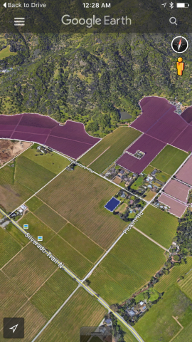
The vineyards will look like this image, but you can change colors, opacity, etc. to make it more usable for your purposes. Of course you can zoom in and the resolution is much better.

As you can see, vineyard names are on the left, and if you double-click a vineyard, it will zoom your view to it.
I’m pretty sure all the vineyards I have in there are correct, but let me know if you see errors. I’m sure I have left out some notable vineyards, but this is a start anyway. If I add more, I’ll post an updated version at the same link.
The fun thing about Google Earth is that you can also open other files to superimpose on the view, like the USGS Geologic Map for Napa County available here: USGS.gov | Science for a changing world
Other great layers for Google Earth are the Napa Geology and Soil Texture maps here:
http://www.napawatersheds.org/app_folders/view/6887
Thanks Eric for posting this.
That is awesome that you have that interest, Eric! That stuff is in deed fascinating…I walk and drive around observing soil types and climate differences. But as soon as I see the words “install” or “download,” my head starts to hurt. A technological dunce. So I can’t see if my tiny spot is on there, but it is around the corner from Eisele Estate Vineyard (no longer any association with the Araujo name, which makes complete historical sense.) Across from Kenefick, pretty much, and surrounded by Frediani Vineyards.
Thank you for sharing this, Eric!
I am a big map nerd. ![]()
Of course your vineyard is included in the map, Merril. I wouldn’t leave out EMH!
It’s the little one in blue here, correct?
Very nice, thank you.
One of the most interesting things, to me, is to be able to observe drainage. I think it is a great clue to what the soil can do for its vines. Perhaps 20 rows down from me is a vineyard with a different slope, different soil, a different way of dealing with rainwater. It floods and sits, and also at harvest doesn’t seem to perform that well. Interesting. A walk up around the corner and one can feel a 5 degree difference…a different breeze, or lack of breeze. In addition to rootstock and clone choices, the sites in themselves hold keys to the mysteries. What fun.
Yes, that is it! Good image. Kind of tiny against Kenefick.
One more thing: I also went ahead and placed another kmz file in the shared folder that gives the outlines of all the AVAs in Napa County.
Looks pretty cool. Can’t wait to get home to try it.
We were just at Round Pond over the weekend they said they use this data to determine some of their picking. For example there is a gravel strip that runs through part of the vineyard. They will pick the gravel and bottle it as a separate designate. Having tasted it, I can see why. Very different than the Cab from other parts of the same vineyard.
Really cool, Eric.
Thanks.
Thanks for all the work. It looks like a great tool to see where things are. If there are ones you are missing and don’t know where to find specific data you can try searching www.everyvine.com. They have quite a bit of vineyards mapped along with clone/rootstock and related wine information (if the owners have provided that). No flyovers or rotation available but pretty thorough mapping of vineyards although there are some exceptions there too as well.
Thank you!!
I agree that Everyvine is terrific - especially for some areas like the Stag’s Leap District. Some of the other regions are not covered quite as comprehensively or accurately. I’m sure they are improving all the time though, and it’s a great resource.