Thanks to another recent thread (the one involving billionaires and their toys), I was reminded of a lingering question that I had never been able to resolve, but I’m hoping that maybe somebody from the board, Doug Wilder or Roy Piper perhaps, could shed some light on.
We all know Screagle has the vineyards with the pretty pretty diagonal planting, as seen in the link above. However, during my somewhat frequent trips up to the valley, I have noticed the parcel that is just slightly East by South East of Screagle on the other side of the hill. It’s the oddly shaped and elongated vineyard that hugs the Silverado Trail. It is in the process of being totally re-planted and I think they may just have the root stock in there at the moment.
Does anyone know who owns this vineyard? Is it Screagle? Is it Bevan?
Can’t seem to figure it out on my own, and I’m hoping someone can help cure my idle curiosity.
So it appears that it is the one directly across the road from Vine Cliff. I think SarahE might be right, if her information is correct. I remember that being buldozed a couple of years ago, which means it actually is a new vineyard. Out of curiosity, how did this land fall into the hand of BV, if indeed it does belong to BV?
Other than the vines needing to mature, can anyone speak to how this new vineyard might perform? Do vineyards themselves (not the vines) need seasoning? If so, how long?
North East from Screaming Eagle, on the steep hill is Backus a Phelps Vineyard. Directly across the street is Vine Cliff, but they have no vines on that piece of their property. Directly South is a new vineyard and I thought it was for Beringer, not BV, but I am not completely sure. Directly North is Harbison on the East side and Tench on the West side.
Vine cliff said they aren’t replanting any vines, so I guess that rules them out. I guess we don’t know exactly to which parcel you’re referring. You can find who owns land at the Napa assessor’s website…
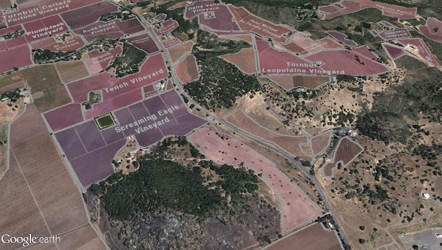
The Oakville Winegrowers Google Earth map (http://www.oakvillewinegrowers.com/oakville_map.html) is a very good resource for vineyards in that area. (Their artist’s rendering map is not as good). The downside is that vineyards belonging to non-members of the winegrowers association are not labeled on the map.
Here is a sample of how the Oakville Winegrowers Google Earth map looks:
Wow! What a great pic! I have looked at that map before, but it has been awhile and they have definitely filled in some more names.
Two things from that shot really stand out to me:
Screaming Eagle is pretty darn huge!
Harbison (tucked in between Tench and Screagle) is super tiny!!!
It does show the parcel that I’m talking about, the one connected to Screaming Eagle, just to the south along the Silverado Trail, but alas no info on ownership.
Yeah, that is a new planting. It is a parcel being developed by Beringer. I hear the owner is the Gamble Family and that Beringer leased it and is developing it. Many years ago I asked about that section and was told most of the topsoil was removed long ago for use in the Rector Dam. This would seem to make some sense as it is several feel lower than Screaming Eagle, but who knows how true that story is. But once they started developing it, it looks like a fairly rocky portion to me as I drive by, so we will see what happens to the fruit that comes out of it down the line.