This fire has exploded over the last several hours. Mandatory evacuation issued for the Russian Ridge Preserve at 11PM. Russian Ridge is on the west side of 35 and Fogarty is across 35 at the northern edge. Then Rhys is further south…going to be a long night. We are about 10 miles away; just took the dog out and the smoke is thick.
Sorry to hear this. Hope it subsides.
Yes, the situation is very serious. We have evacuated Alpine, Horseshoe, Skyline cave and Centennial Mountain.
With so many fires, CalFire is spread very thin.
Driving home from Sonoma Mountain last night (as it was raining ash on us, so we figured we should just leave a day early), we could see the fire off of 280 near San Carlos. Not sure exactly what fire it was, but it was surreal to see that kind of intensity and smoke so close to home. I’m just off 280 and Woodside road, so not really near the fire, but the smoke is crazy now and there is ash all over the place now at the house.
Likewise here in Atherton.
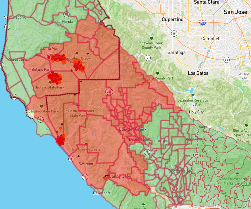
Latest evac map…Cal Fire projection on containment is September 1st ![]()
Good luck and be safe. I hope it gets contained very soon!
JP
Even that seems optimistic. Ugh.
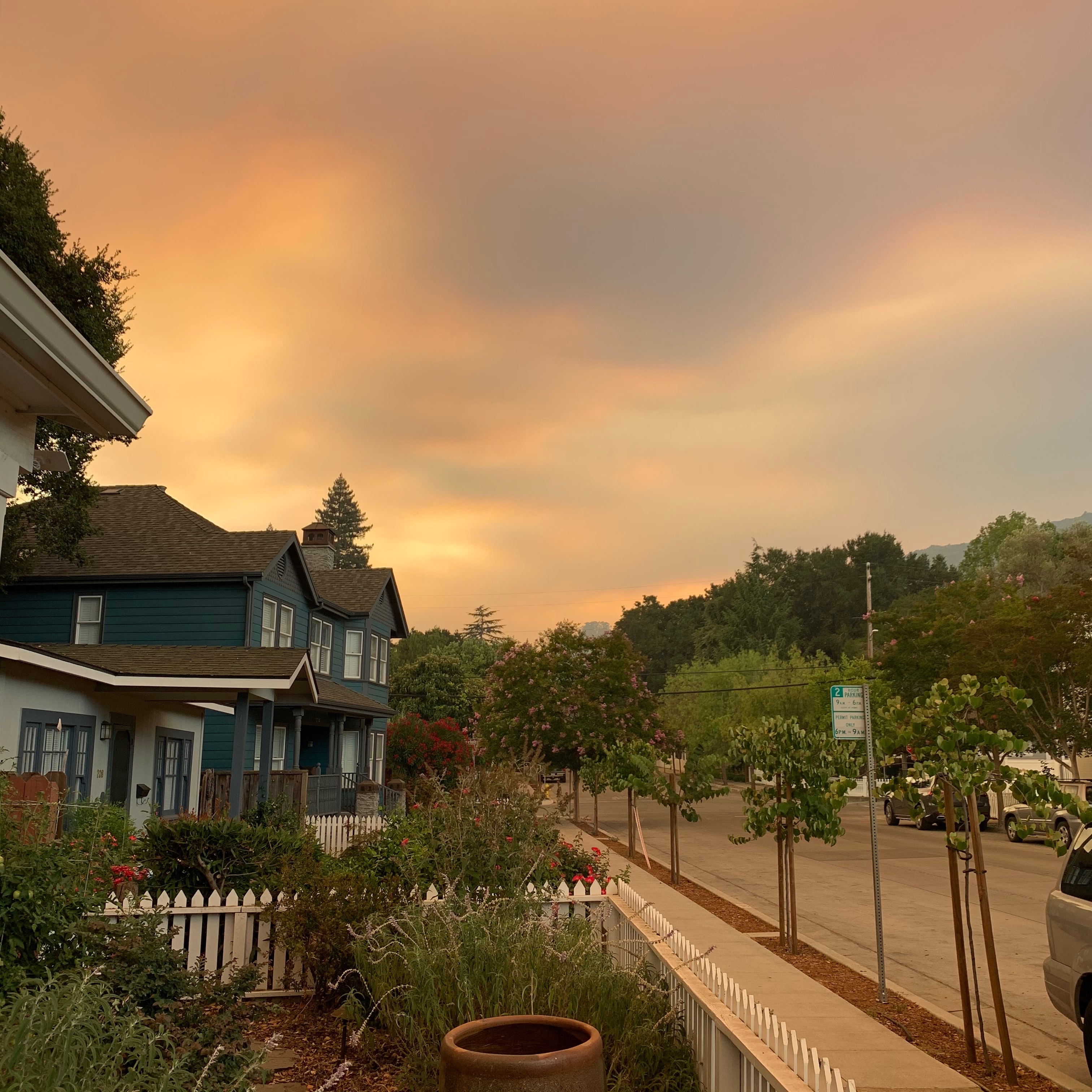
This is downtown Los Gatos looking south today, about four hours before sunset (iPhone photo with no filter). It’s actually lighter now, about an hour later, as that cloud is moving slowly east and the sky is relatively clear to the northwest.
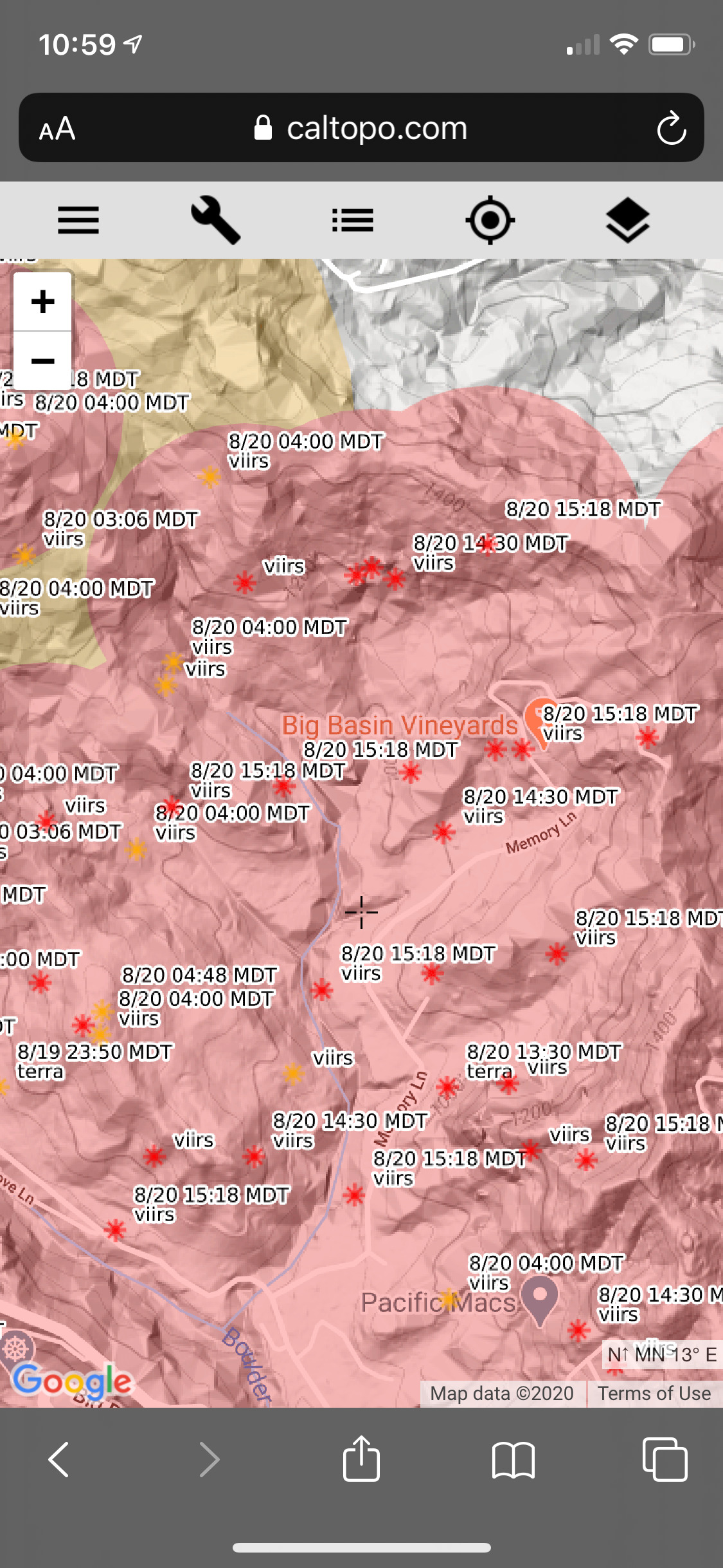
Big Basin’s tasting room is very close to Big Basin State Park HQ, which has burned. The road to Big Basin from Boulder Creek is now closed. I really hope the winery is OK. Its crazy how fast that fire ripped through the park. Now Felton is being evacuated. This is getting crazy.
Just got pictures from Jack Galante in Monterrey. He has had damage and showed pictures of the SLH on fire including the SLH vineyards.
Not only are Boulder Creek through Felton evacuated, Scott’s Valley residents are being told to be ready for evacuation. Evacuation warning for everything west of Highway 17. The head of Cal Fire cannot do anything with aircraft because of the smoke remaining in area (not much wind). And, the terrain in so steep they can’t fight it on the ground. There is very little they can do to stop the fire. Have never seen anything like this in Santa Cruz County- and I’ve been a resident for over 50 years. Whoa!
There is also a lot of fuel in that area because they get so much rain during the rainy season.
-Al
Oof, so sad to see. Here’s a relevant article that is seemingly getting updated (last one was at 1:36 am this morning):
This is very very bad.
So, legitimately trying to get educated on this subject. I thought the issue was drought and heat, according to at least some press. Totally get “a lot of fuel” but how does too much rain factor into a high fire risk? Thanks in advance. Trying to get smarter on this stuff.
There are a lot of different microclimates, particularly around Northern California. Santa Cruz mountains tend to get more rain during our rainy season than most other areas, with the exception of the true north coast. There are large growths of redwoods, for example, from the winter rain and cooler, foggier climate. That also drives the growth of plenty of ground brush and smaller bushes and trees. But once the rainy season is over, around May, things dry out, making it a big fire risk. At this point, we haven’t had rain since May, with the exception of the freak tropical remnant coming up from the south that sparked all these fires.
More rain = more plant growth = more fuel when it dries out.
Boulder Creek averages something like 40" of rain per year, one year they had 110". It’s basically a non-tropical rain forest. It’s very difficult to walk through an undeveloped area unless on a road or trail, it’s dense trees and underbrush. But, the rain comes almost entirely during the rainy season, so it also dries out. Most of the area also hasn’t had a major fire in many years. So, the are has lots of fuel, a number of lightning caused fires, and it’s a very challenging area to fight a fire with the trees and underbrush and steep terrain. It’s different than Napa, but may be even more challenging.
-Al
It’s really disheartening - almost 50,000 evacuees, many homes burned already, headquarters of California’s oldest state park gone. Several vineyards and wineries at risk, the map does not look good for Big Basin: